
Why the use of drones in Philippine construction is growing fast
The rise of new drone technology is driving innovation in an absolutely huge range of industries – and construction is leading the way.
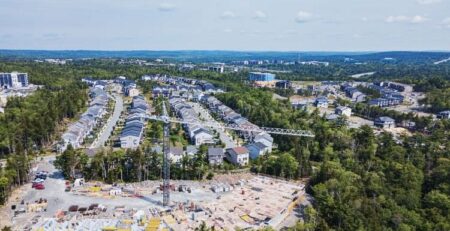
No commercial industry has adopted the use of unmanned aerial vehicles (or UAVs) as fast as construction has in the past few years. In 2018, the use of drones in job sites around the world increased by 239% from the previous year based on research by international drone intelligence company DroneDeploy.
This trend continued in 2020 and has now reached the Philippines.
This fast growth shouldn’t be a surprise because even from a surface level, pairing UAVs with construction makes a lot of sense. Drones excel at collecting huge amounts of data at a fraction of the time, manpower, and money traditional methods need, and with higher safety.
Getting reliable geodata is an essential step in any project, but the resources this requires and risks it comes with can bog down progress and be a headache for any site manager – until modern drones and data software came along.
How drones are used today in construction sites and development projects
The most frequent roles remotely piloted aircraft like drones play are in data collection and surveillance. These are areas that are typically done on foot by teams of engineers and surveyors, but that drones can achieve with significantly smaller resources.
The most common applications today are:
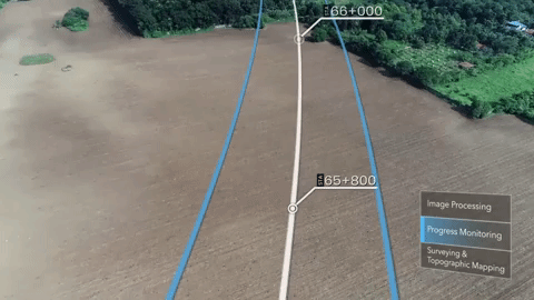
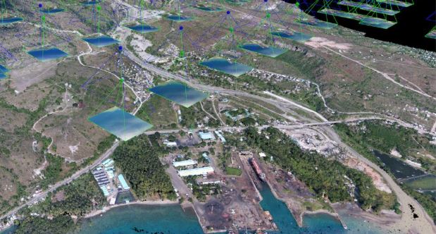
1. Conduct Faster and More Comprehensive Site Surveys
Aerial drones can quickly scan a large area to make measurements and capture high-resolution images. There is a high amount of flexibility on the type and amount of data collected, depending on the payload equipped such as LIDAR, RGB cameras, and multispectral cameras.
They can make multiple rapid passes from a variety of angles not possible through an on-foot survey.
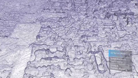
2. Generate Super Accurate Contour Lines & Topographic Maps
Modern UAVs are extremely accurate and are used to visualise geodata through maps and contour lines, and also plan roads and highways for construction.
They are often paired with data analysis software to reliably identify and measure slopes or elevation areas that need to be considered for construction planning.
3. Safer Building & Structural Inspections
Drones equipped with high resolution cameras are regularly deployed to reveal any flaws or damage on buildings and avoid placing any personnel at risk, or putting resources into scaffolding. In project sites with potential leaks or power generation, they can be equipped with thermal sensors to identify fluctuations in heat and temperature.
If required, the images and video collected can also be combined with other data to produce a 3D model of the structure that engineers can analyze.
4. Remotely Measure Volume of Stockpiles
Site progress can be tracked by measuring the amount of stockpiled materials through an aerial survey.
Often used in mining and quarrying sites, drones can be configured to fly overhead and use photogrammetry to create a 3D model accurate up to the centimeter level and measure volumes with the help of specialized analysis software.


5. Streamline Supply Chains and Workflows
When drones are deployed regularly, they can quickly and accurately evaluate the rate of progress and how much work is left to be done.
This results in real time data that is extremely useful to organize supply chains and plan orders in advance as part of a streamlined workflow.
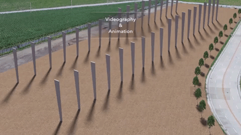
6. Improve Stakeholder Reports and Proposals with Custom Graphics and Building Models
UAVs are unmatched when it comes to capturing unique video and imagery of construction sites from multiple angles. Drone footage are often combined with graphics and statistics through video editing to create attractive and easy to understand reports for both managers and clients.
This is also used for Building Information Models (BIM) to bring projects to life with animation that visualize each step in the construction process.
The major advantages of drones & UAVs in Philippine job sites
The on-site improvements drones bring in safety, efficiency, and reduced costs are the major factors behind its rise in construction.
Drones significantly cut down on health and safety risks for staff and personnel on the ground.
As remotely piloted aircraft, they can survey any project site with heavy machinery or high-risk environment, and any unexplored terrain. With proper planning, they can take off from anywhere and access areas that would be impossible or extremely time-consuming to enter on foot. These UAVs can be sent to inspect steep slopes, active roads or highways, or building progress without taking on additional risks.
The time it takes to survey and make accurate measurements for distance and volume is also massively reduced.
Experienced drone operators can survey large areas and analyse data in a few days instead of several weeks for reports and models compared to traditional methods. Deploying drones also lets other activities on the site continue instead of forcing project managers to pause any heavy machinery and halt progress which would be required to let on foot surveyors in the construction site. There are no downtimes when UAVs are utilized.
As a result of the speed and high coverage area of drones, surveys now require less manpower and money to complete.
There is no need to remove staff from their area of work to reallocate them into survey teams every time a site update is due. A single team of external drone operators can survey entire construction sites independently with minimal guidance needed from the project manager. This results in lower costs and less resources spent overall for both personnel and equipment.

Summary: The growing role of drones in construction and real estate
Drones have evolved from an experimental method into a competitive advantage and essential tool for project managers who value efficiency, safety, and reliability. They now play a critical role in many construction sites in the Philippines and its popularity is only increasing.
Technology and software continues to evolve today and it is almost certain that even more applications for UAVs and remotely controlled vehicles will be found over the next several years.
Leave a comment or ask a question here: